0 min
Overview
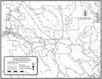
"Middle Ridge is well known to locals, it's one heck of a single track and one of the few that you don't have to Climb 1500 feet or more for the pleasure of the descent that privilege waits to greet you at the end of the single track as you climb your way back out of the confluence of the various forks of the Coyote Creek. So as you come into the visitor center you'll note an asphalt road off to the left, all points start by climbing this 100 yard grind to the gate. From the gate follow the Manzanita Point Road a dual track fire road. Go a mile or so then as you drop into a saddle between ridges you'll note an information sign at a trail junction on the left. This is the junction of a series of single tracks. You want to go on the Flat Frog Trail the hard left of the three options. Flat Frog is a fun single track with wonderful views of the various ridge lines running through Coe just short of 3 miles it's an easy fun ride for anyone. Flat Frog drops you at Hobbs Road another fire road go left and cross the creek and begin a steep difficult climb of about 200 to 300 feet of gain. As you top out Middle Ridge a single track breaks off to the right, if you start a steep descent you've gone too far and trust me this part of the road is no fun to climb back out of. Ok so now you're on the Middle Ridge single track hold on for the fun. Middle Ridge is 5 plus miles of steep fast single track with only a few technical areas thrown in to keep you honest. Once you start there is only two legal ways out, back the way you came or the bottom at Poverty Flat meaning you have to climb 1500 feet, you can get in serious trouble on a hot day so... OK so you've had a great time on the Middle Ridge you've bottomed out at Coyote Creek/Poverty Flat now you have three options out. 1) The road most traveled is Poverty Flat Road a grinding fire trail that takes you back to and merges with Manzanita Point road, a tough joy less ride. 2) Cougar Trail, a grinding single track (no fun up or down) off of Creekside Trail (see below), 3) My
Trail Stats
0.0 km
0 m
0 m
0 m
—
Photos
Coe Middle Ridge
Coe Middle Ridge