0 min
Overview
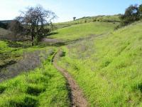
"Santa Teresa Park comprises over 1,600 acres, and sits in the southeast corner of San Jose, off of Bernal Road, near the Junction of Highway 85 and 101. The park is an excellent place to visit in the spring, between the rains. Wildflowers are in full bloom and are abundant. The creeks are running and the wild turkey are roaming about. The trails here can be quite exposed and hot during the summer - add at least 10 degrees to the readings for San Jose. The park is mostly closed during winter as the clay-filled soil is much too soft to ride on. If the soil is wet at all the park will not be open (Santa Clara County has a trail closure line you can call and check). The terrain is mostly hardpack/loose-over-hardpack with some serious rocks to boot.<br /> <br /> There can be some equestrian (horse) traffic, but there is usually none on weekends - though there are more hikers on weekends. I've not found it to be a problem.<br /> <br /> For mountain bikers, the most popular trail in this park is probably descending Rocky Ridge. This is a very fun, technically intermediate level trail. If you're a beginner and have not ridden over a lot of rocks before, parts of this trail will seem quite advanced to you at first. Full-suspension bikes are probably your best bet here. The top of the trail is flowy, turning into more serious rocky terrain in the second third of the trail. It's roughly a 2-mile descent and over 500 of elevation to get to the bottom of the trail, which is the center of the park.<br /> <br /> There are many fun and quite steep ways to get to the top of Rocky Ridge trail. You can do an up-and-back on the trail itself, or park in any of there areas in or out of the park and make a loop out of it (there is a parking charge inside the park). Most mountain bikers stick to the trails south and east of Bernal avenue, since they contain the most single track. Either direction on Ohlone or Hidden Springs trails is great. Get ready for some steep climbing. Unfortunately, there is no way to shuttle
Trail Stats
0.0 km
0 m
0 m
0 m
—
Photos
Santa Teresa Park
Santa Teresa Park